Severe Weather Briefing
April 26, 2016
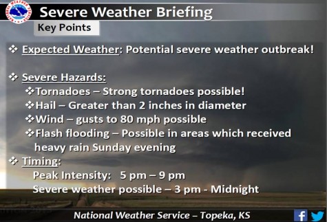
Tonight, April 26th there is a potential threat for severe weather. The Geary County Emergency Preparedness Office provided updated weather information for tonight’s possible storm. A summary of the storm will be provided below describing key details in tonight storm. The expected storm will consist of hail, greater than 2 inches in size, wind gust up to 80 mph, and flash flooding in areas that received heavy rain on Sunday. It is anticipated that the storm rill reach peak intensity at approximately 5 pm-9 pm, with severe weather possibly starting around 3 pm.
When approaching a severe weather crisis it is imperative that people are aware of the signs and protocols of severe weather.
If a tornado is expected, you should look for a dark sky, large hail, dark rotating low-lying cloud. Tornadoes often strike quickly with little to no warning, so, when seeing the signs shelter should be taken immediately. Essential terms to know when facing a tornado is:
Tornado Watch- Tornadoes are possible. Remain alert for approaching storms. Watch the sky and stay tuned to weather Radio, commercial radio or television for information.
Tornado Warning- A tornado has been sighted or indicated by weather radar. Take shelter immediately.
During thunder and lighting/hail storms be sure to postpone all outdoor activities and remain inside until the sky clears. Before the storm, unplug any electronic equipment. Dead or rotting trees and branches should be removed to prevent risk of injury.
Although it is never guaranteed that you will be protected from the storm, it is best to take the necessary safety precautions prevent any casualties or fatalities.